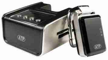
ATP PhotoFinder mini review
One of Google Picasa's best features is its ability to plot photos on a map of the world. Doing this manually can take time, but the PhotoFinder mini automates the process. It's a GPS device that logs your location at 10-second intervals.
Later, you plug it into the supplied docking station along with the camera's memory card. Geographical coordinates are embedded into your photos by looking up the GPS position for the time and date the photo was taken. This information is saved as part of the photos' EXIF metadata, which is compatible with Picasa, Google Earth and a range of other software.
Other than setting the time and date on the camera, the process should be easy. However, we were initially unable to tag any photos, and found the manual to be astoundingly unhelpful. After a few email exchanges with ATP's technical support, we were supplied with new firmware along with some convoluted instructions for installing it. From then on the device mostly worked fine, but it still refused to tag some photos, while others caused it to crash.
The internal battery lasted for a respectable 20 hours, while its 128MB memory is enough to store 10 days' worth of GPS data. GPS accuracy for photos wasn't perfect, producing errors of up to 300 metres, though it was usually within 100 metres of our true position. It transpired that this was because although the GPS readings were taken every 10 seconds, our photos' EXIF data was accurate only to the nearest minute.
A welcome extra feature is the ability to convert native GPS data into KML files, which appear as plotted lines in Google Earth. This was very accurate, with our route being plotted to within about five metres.
Geo-tagging is a fun idea, but we're not sure if it's worth £97. It's reasonable if you have a more serious use for the data; surveyors and estate agents, for example, might find it invaluable. However, even the most enthusiastic user will be frustrated by the PhotoFinder's reliability issues.
